- OpenStreetMap -
The long debate of land-use mapping with OpenStreetMap in Belgium
12.03.2018 - OpenBelgium - LLN
Julien Minet

This presentation and scripts are available on github.com/nobohan/OSMLanduseAnalyzer.
Why?
Presentation at FOSS4G.be last November
Discussions within the OSM community
Objectives
- 1. Quantitative assessment of land-use/land-cover mapping in OSM in Belgium
- 2. Have a look at some applications of OSM land-use data.
- 3. Discuss some cases/issues
- GOAL: Some Belgian conventions on land-use mapping with OSM in Belgium
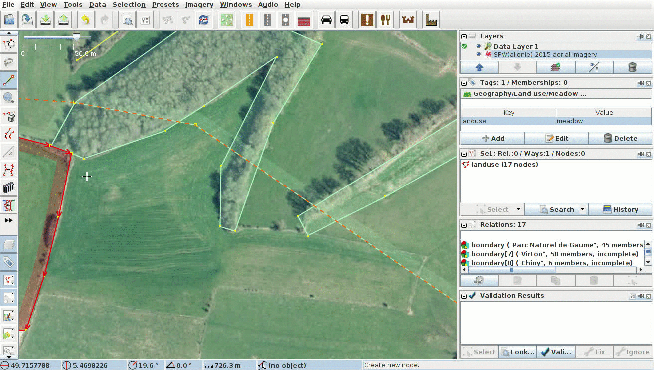
How land-use/land-cover is mapped in OSM?
- by digitalization on aerial imagery, with user/terrain knowledge
- by semi-automated import from other database (including Corine Land Cover) (but not so much in Belgium)
Quantitative assessment of land-use/land-cover mapping
[Quantitative assessment of land-use/land-cover mapping]
Results
Global share of "land-use" tags in Belgium
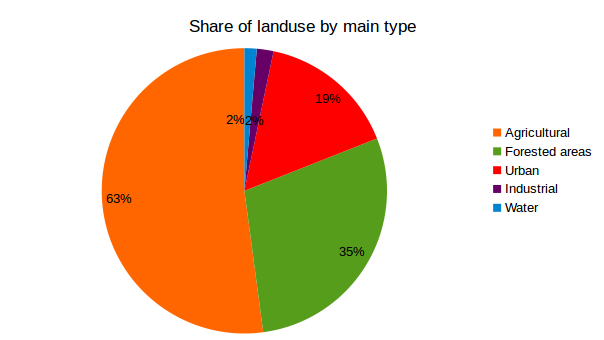
Note that many "land-use" polygons overlap to each other. Sum of classes > 100%!
OSM data was downloaded from geofabrik on the 10/10/2017.
See methodology on github.com/nobohan/OSMLanduseAnalyzer.
[Quantitative assessment of land-use/land-cover mapping]
Results
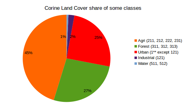
Share of some (not all) land-use class in Belgium in CorineLandCover
[Quantitative assessment of land-use/land-cover mapping]
Results
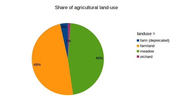
Share of agricultural "land-use" tags in Belgium
[Quantitative assessment of land-use/land-cover mapping]
Results
Part of forested "land-use" that is defined by leaf_type in Belgium
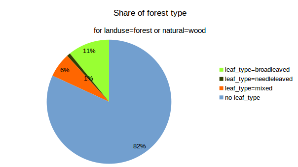
The deprecated `wood=*` tags are not considered here.
[Quantitative assessment of land-use/land-cover mapping]
Results
Part of forested "land-use" that is defined by leaf_cycle in Belgium
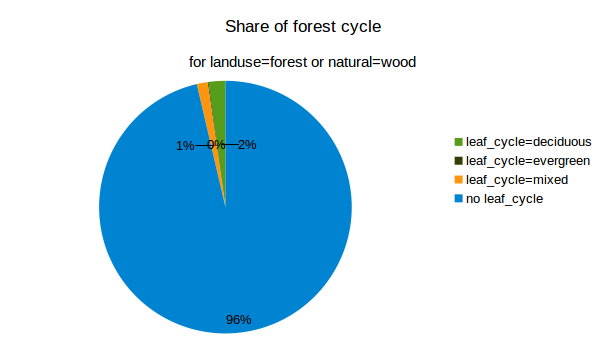
The deprecated `wood=*` tags are not considered here.
[Quantitative assessment of land-use/land-cover mapping]
Results
Total coverage of "land-use" tags by provinces in Belgium - OCTOBER 2017
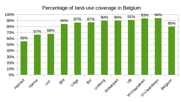
Overlapping "land-use" polygons were dissolved before computing this coverage!
OSM data from geofabrik, 10/10/2017.
See methodology on github.com/nobohan/OSMLanduseAnalyzer.
[Quantitative assessment of land-use/land-cover mapping]
Results
Total coverage of "land-use" tags by provinces in Belgium - MARCH 2018
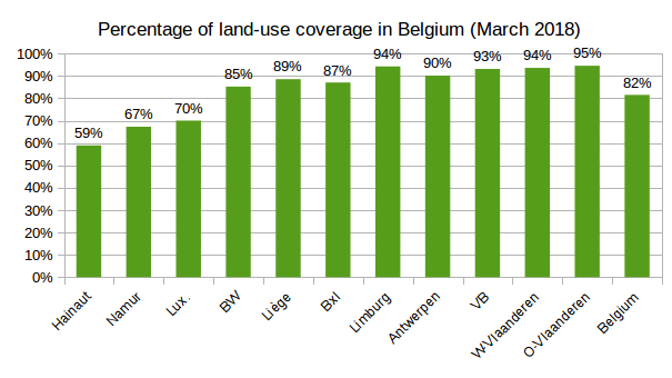
Overlapping "land-use" polygons were dissolved before computing this coverage!
OSM data from geofabrik, 07/03/2018.
See methodology on github.com/nobohan/OSMLanduseAnalyzer.
Applications
[Applications]
What applications of OSM land-use/land-cover data?
Plain cartography
"Do not map for the renderer" they said...
... but map for the renderers! (paper maps, OpenTopoMap, Thunderforest maps & many many more)
[Applications]
What applications of OSM land-use/land-cover data?
In science
- support earth observation interpretation / classification: example the lifewatch project.
- ecological network analysis
- as base layer for hydrological modelling / flood forecasting
- as base layer for climate / biogeochimical cycles modelling
[Applications]
What applications of OSM land-use/land-cover data?
Land-use planning, urbanism
[Applications]
Other Volunteered Geographic Information system focused on land-use
- Geo-wiki challenges: gamification of land-use / vegetation recognition
- EU research project on land-use data from VGI : LandSense.eu
OSM land-use mapping issues
[OSM land-use mapping issues - geometry]
1. Should land-use nodes be shared with nodes of adjacent (linear) features?
See this discussion on the OSM forum
--> We should not
| PROS | CONS |
|---|---|
|
Geographic features are digitalized with keeping their real ground footprint This allows more features to be mapped in the future (hedges, ditches, ...) |
The "OSM land-use" database is not continuous Nodes are somehow duplicated: increase in database size |
[OSM land-use mapping issues - geometry]
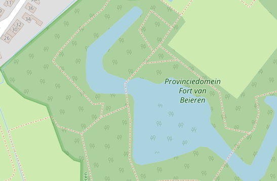
2. Should we superimpose "land-use" features?
See this discussion on the OSM forum.
--> Why not? (it depends)
[OSM land-use mapping issues - geometry]
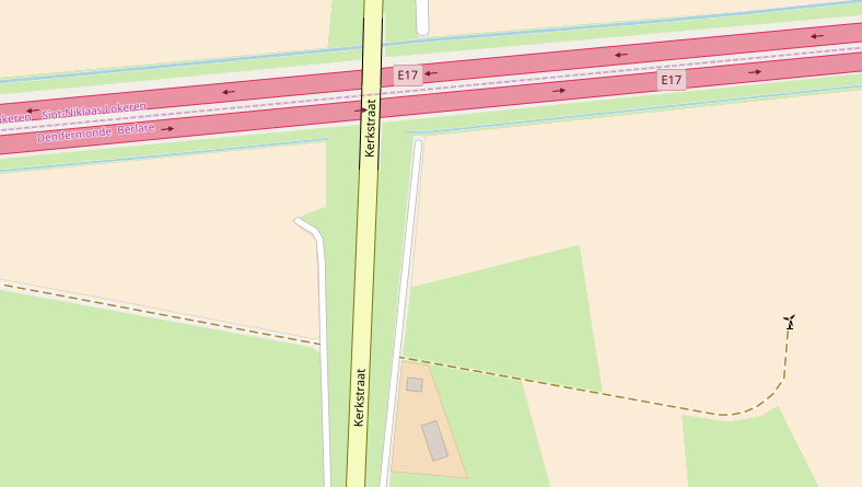
3. How do we parcellize things, such as gardens, agricultural lands and forests?
[OSM land-use mapping issues - tagging]
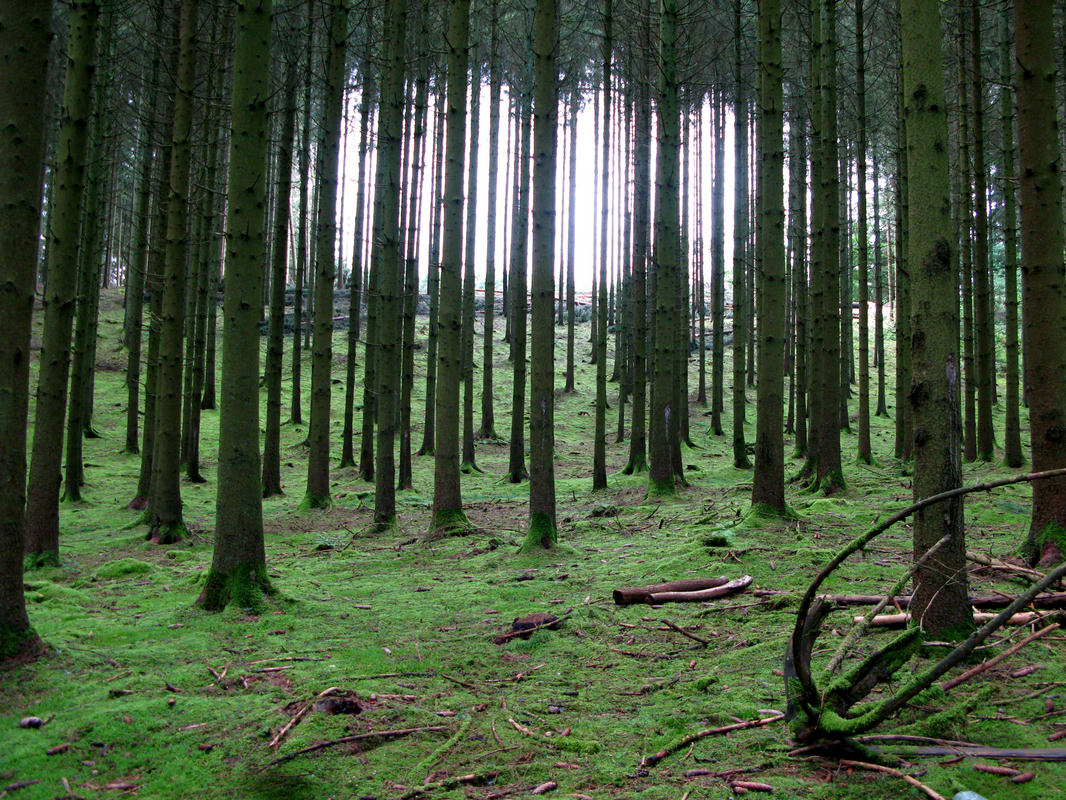
4. natural=wood vs landuse=forest for mapping forests in Belgium
See this discussion on the OSM forum and the Forest wiki page
--> I prefer landuse=forest
[OSM land-use mapping issues - tagging]
5. landuse=farmland vs
landuse=meadow
for mapping meadows in Belgium
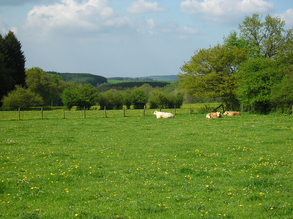
Arable land: landuse=farmland + crop=*
Grazed meadows: landuse=meadow + meadow=agricultural + animal=yes
Hay meadows: landuse=meadow + meadow=agricultural + crop=grass
These tags are often (unappropriately) mixed up!
[OSM land-use mapping issues - tagging]
6. Better describe leaf_type | leaf_cycle in forests?
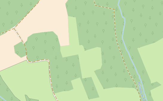
Note that forests are rendered by "leaf_type" since the last carto-osm update in August 2017
[OSM land-use mapping issues - tagging]
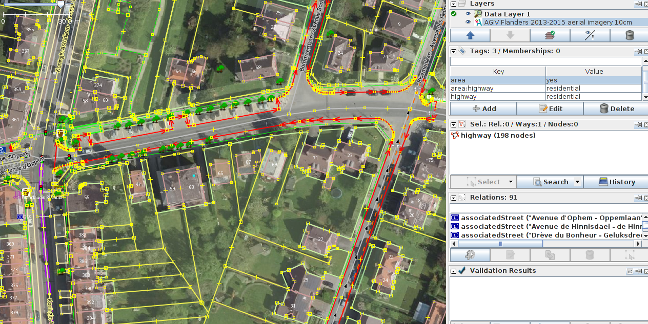
7. Which tag for highways areas? landuse=highway vs area:highway=*
[OSM land-use mapping issues - tagging]
8. Confusion between land-use & land-cover in OSM
e.g., landuse=grass is a land-cover tag.
landcover=* tags are not rendered
natural=* tags are often pure land-use (and not natural features, at least in Belgium). For instance, most of Belgian ponds are artificial and are tagged as natural=water+water=pond.
References
Some scientific articles on the issue:
- Production of a land-cover map from OSM and automatic gap-filling with remote sensing data: Schultz et al., Open land cover from OpenStreetMap and remote sensing, International Journal of Applied Earth Observation and Geoinformation, 2017. [link] + the blog article
- Assessment of land-use classification and accuracy in OSM in Vienna, Austria : Arsanjani et al., Toward mapping land-use patterns from volunteered geographic information, International Journal of Geographical Information Science, 2013 [link]
- Comparison of OSM against Corine Land Cover in Portugal : Estima & Painho, Exploratory analysis of OpenStreetMap for land use classification, 2013 [link]
- Accuracy of natural features in OSM (several countries): Winstanley, A study of data representation of natural features in OpenStreetMap, Proceedings of GIScience, 2010 [link]